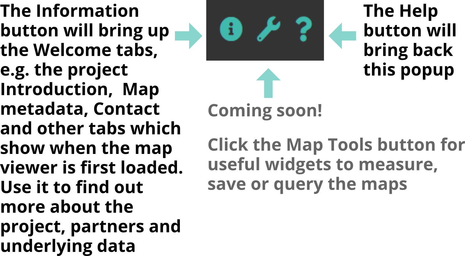
Welcome to the GLNP Natural Capital mapping project
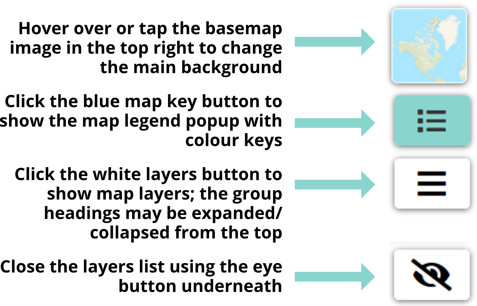
About the map layers
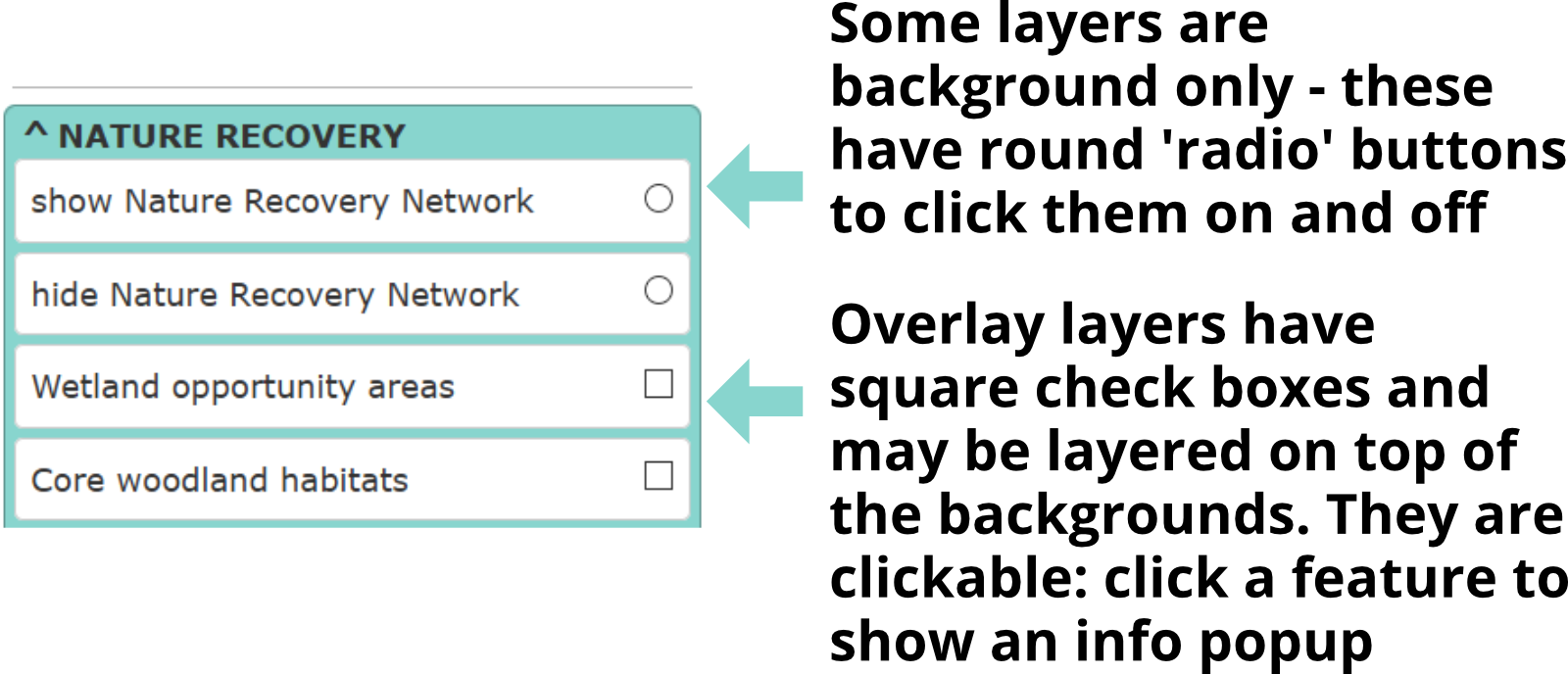
Click a category below to show/hide information about each of the map layers:
Description
Version: 1.1 Aug-Nov 2020
Ecosystem services are the benefits provided by ecosystems that enable human populations to live and thrive. A loss of natural capital such as core habitats and healthy soil leads to a loss of associated ecosystem services, with adverse impacts for people and wildlife. In the worst case scenario a serious collapse in ecosystem services may make some areas uninhabitable altogether; a deterioration in ecosystem services, if not lethal, will certainly cause a loss of human quality of life and increased pressure on remaining wildlife populations.
Repairing or replacing services provided by a healthy environment may prove either impossible or prohibitively expensive. The need to identify, protect and improve these services whilst we still have them is now considered crucial to ensure a resilient and sustainable future for both wildlife and people.
The Gloucestershire Natural Capital Mapping Project has identified thirteen key ecosystem services which we benefit from directly as a result of the county's natural environment. The majority have both a baseline map showing the extent of the existing service, and an opportunity map showing the degree to which a service is being delivered where it is needed. The services fall within four main categories and are derived from a wide range of source data and methodologies. Contact GCER or GLNP for information about how you can obtain or reproduce copies of these maps.
Click on an ecosystem service below for more details:
Supporting benefits:
Provisioning Services:
Regulating Services:
Cultural Services:
Version date: March 2021
The Tree Opportunities layer is intended to complement the Gloucestershire Tree Strategy. The Tree Strategy (September 2020) is the result of Gloucestershire Local Nature Partnership partners' joint effort to guide tree planting and management in the county. The Tree Strategy Vision is:
"A thriving network of sustainably managed trees and woodlands covering at least 20% of the county, delivering resilience and connectivity for people, wildlife and the economy."
The first of seven guiding principles for the Strategy relates to increasing the current level of tree cover:
"1. Establish the right tree in the right place for the right reason, through both active planting and
natural regeneration as appropriate."
The tree opportunities map layer aims to show where the best opportunities are to be gained for ecosystem services by planting more trees. The map scores are a combination of the Carbon storage, Water flow regulation/flood risk, Local climate regulation, and Air pollutant removal opportunities layers, with each one given equal weighting. Thus, the highest score is 40, or ten out of ten for all the contributing layer scores.
The Tree Opportunities map does NOT indicate locations which are unsuitable for tree planting e.g. due to the presence of useful existing habitat. It should therefore be used in conjunction with the Nature Recovery Network and biodiversity layers to analyse the best places for planting new trees and/or encouraging new tree regeneration.
Click here for more details about the Strategy, a full list of guiding principles, and a download link to the strategy document (opens in a new tab).
Contact GCER or GLNP for information about how you can obtain or reproduce a copy of the Tree Opportunities map layer.
Description
Version: 1.2 June 2020 (Beta - working draft version)
Nature Recovery Network mapping aims to show the prioritised distribution of opportunities for creating a more resilient network of habitats for people and nature. Four categories are included:
- Open habitat (core habitat: largely grassland but also some lowland heath)
- Woodland (core habitat: semi-natural woodland)
- Arable (coming soon! core habitat: farmland bird and specialist arable plant habitats) and
- Wetland (core habitat: all open water and wetland habitats). This layer is treated as an overlay to the other categories
Because of their significance in the County, Traditional Orchards (a Priority Habitat) have here been included as a separate habitat layer. Note that this layer is maintained by the People's Trust for Endangered Species and provided under an Open Government licence via the Natural England Open Data portal under the same conditions of use as other Open Data Portal layers (see the entry for AONBs).
View the Traditional Orchards layer metadata here.
Rationale
Opportunity for the four main habitat categories to be extended into larger and more joined-up networks is calculated using the concept of 'cost distance' - in other words, for a key suite of species typical of the habitat type, how easy is it for those species to spread given that some surrounding areas 'cost' (in ecological terms) more than others to move through? A score for the cost distance is then combined with a number of other opportunity scores and an assessment of constraints to habitat restoration/creation.
The network thus illustrates both the existing hot-spots of habitat, and also the potential benefits of improving the landscape permeability (reducing the 'cost') to create better networks both for biodiversity and ecosystem services. This is a very complex calculation that isn't always easy to express on a map! Despite the difficulties however, the NRN layer, although generalized, is still strongly indicative of where the priority opportunities lie for landscape-scale habitat restoration.
Scoring
Areas shown on the NRN map are broken into high, medium and low scores for nature restoration opportunity - plus the existing Priority Habitats which form the core baseline. A high opportunity score will have a bolder colour on the map, and represents the opportunity for 20% coverage of core habitat. A medium opportunity score offers a 10% increase; other areas are classed as low but can still provide opportunities to improve the resilience of the network if the right project is proposed. Importantly, even low-scoring areas may offer a chance to improve the permeability of the wider countryside to species movement.
Core habitat patches from each network are shown here in the same map layer group as the main NRN layers. These are what the networks are built around and the aim is to assure the long term survival of the species associated with these patches. A core habitat patch is an area of contiguous priority habitat (NERC Act section 41 definition) or semi-natural habitat. Patches of habitat are considered contiguous if gaps between them are no greater than 10m.
Source layers
The NRN layer and accompanying Wetland Opportunities and Core Habitat overlays all rely on a detailed habitat inventory of Gloucestershire which is compiled from a wide range of sources. These include Natural England's Priority Habitat Inventory, the latest CEH Land Cover Map, Ordnance Survey MasterMap, Gloucestershire Wildlife Trust's Phase 1 Habitat Survey and other site survey data, and specialist habitat assessments such as the UK National Forest Inventory and the People's Trust For Endangered Species' Traditional Orchards distribution map.
Methods and limitations
Click the download buttons above for a full technical guidance document including definitions, methods and limitations, and a table of summary details for each map layer.
Care should always be taken to prevent degradation of any existing valued habitats, network connections or geological or historical features. The NRN map layers should be considered as guidance only as they are generated from best available data and may not always reflect the true picture on the ground. They are not a substitute for expert advice but should be used to inform decision-making.
Future upgrades
The current NRN layer is a 'beta' version which lacks the final habitat category - Arable habitats. This category is of particular importance for farmland birds and arable plants, but hasn't been assessed fully during 2020 due to Covid-19 related farm survey restrictions. Future NRN layer versions will include core Arable habitats, an updated NRN layer and any major updates to other underlying habitat inventory data.
Data uses and restrictions
Image extracts from this website may be made (eg by utilising the 'Screenshot' tool) and used in reports, provided Gloucestershire Wildlife Trust and Gloucestershire Local Nature Partnership are attributed, along with the version number of the underlying map. Raw GIS data may not be copied or made use of without first agreeing authorisation from GWT, as it contains licensed, proprietary data (see the main Acknowledgements tab).
Description
Version date: July 2020
The existing connectivity of the woodland and the open habitats networks are modelled using the concept of 'cost distance' – for each of the networks an ecological ‘cost’ to movement through the landscape is assigned to every habitat or land use type. This governs the score for dispersal distance of a generic, model species, where: allocated dispersal distance / ‘cost’ = distance moved into the landscape.
The layers illustrate a number of different dispersal distances for each ecological network to indicate the existing level of connectivity for different species groups.
The lowest (500m) dispersal distance illustrates the core network, as 500m or less is considered to be applicable to the dispersal limitations of many invertebrates, vascular and lower plants on which ecosystems are built.
Source layers
See NRN above.
Methods and limitations
More detail about the connectivity mapping is included in the NRN technical guidance. Click here to download the technical report. Click here to download NRN map layer summaries including connectivity map layers.
This is a very generalised illustration of existing connectivity to give an idea of functional connectivity for generalist species that can be viewed at a county scale. If particular species are being targeted you should run the analysis using parameters specific to those species - see the technical report for how to approach this.
Future upgrades
The habitat connectivity layers rely on our underlying knowledge of Gloucestershire habitats. Major changes to the habitat inventory are likely to result in updates to the connectivity map; please check the version date when comparing maps.
Description
Version date: July 2020
Resilience is the ability to bounce back from or adapt to a challenge or disturbance. The Resilience maps display two simple measures of resilience:
- Core habitat patch size
- Area of core habitat within a core network
If a habitat patch or network is below the minimum threshold, it is unlikely to survive with a full suite of species long-term, i.e. it is not resilient, and extinctions will occur.
Source layers
See NRN above.
Methods and limitations
More detail about the resilience mapping is included in the NRN technical guidance. Click here to download the technical report. Click here to download NRN map layer summaries including resilience map layers.
This is a very generalised illustration of resilience to give an idea of priorities at a county scale to guide project planning. If particular species are being targeted the analysis will need to be run using parameters specific to those species.
User guidance
Different user groups will need to use the NRN and resilience mapping in different ways to answer their particular needs. For this reason, specific guidance is likely to be available from the following:
- Local Planning Authorities and the planning process
- Environmental Land Management System (ELMS), organisations’ or individuals’ land management planning
- Landscape-scale nature recovery project planning
- Woodland creation or expansion plans
Future upgrades
As with the connectivity data, the habitat resilience layers rely on our underlying knowledge of Gloucestershire habitats. Major changes to the habitat inventory are likely to result in updates to the resilience patch metrics and hence the map; please check the version date when comparing maps.
Description
Version date: May 2021
Areas scheduled by Historic England include archaeological sites, a wide range of ancient monuments, parks and gardens and sites of historic battles. Note that not all notable parkland in Gloucestershire is 'listed'; parkland also
features on the core woodland habitat layers as it is a Priority Habitat in its own right. In many cases a site of interest will have more than one reason for its importance: some sites in the historic features layer may also be of
interest for geological or biological features.
Data uses and restrictions
The Scheduled Ancient Monument, Battlefield and Parks and Gardens layers are freely available from Historic England's GIS data download page. Historic England request that an attribution is always included with their data; an example attribution, and other licencing and metadata information, is included with each download from their downloads page.
Version date: August 2020
County, District and Parish boundaries are derived from the Ordnance Survey Data Hub Boundary-Line product. Usage is covered by an Open Government Licence; the boundary dataset is free for anyone to use.
Version date: September 2020
This layer is freely available from Natural England's Open Data Hub
View the metadata document here.
As with the administrative boundaries, AONB outlines are free to download and use.
Description
Version 2.2: December 2016
Nature Improvement Areas (NIAs) resulted from a Natural Environment White Paper in which Defra set out a vision for a suite of landscape-scale initiatives. The aim of NIAs is to ensure that land is used sustainably to achieve multiple
benefits for people, wildlife and the local economy. In addition to 12 NIAs of national status, areas may be decided locally wherever the opportunities or benefits are greatest, driven by the knowledge and vision of local partners. This was the case in Gloucestershire, where the Gloucestershire Local Nature Partnership agreed 5 NIAs:
- Forest of Dean
- Severn Vale
- Cotswold Scarp
- Cotswold Valleys
- Cotswold Water Park
The NIA layer consists of simple outlines for each NIA; click on an area to see its name and basic details.
Future upgrades
Gloucestershire's NIAs are likely to develop alongside the Nature Recovery Network to form a framework for effective landscape-scale projects. They may be amended or extended in future, or incorporated into nature recovery areas based on Nature Recovery Network models.
Data uses and restrictions
The NIA map layer is free to use for any purpose; please always include the relevant version number and a GLNP attribution.
Description
Version 1.1: December 2011
The combined Strategic Nature Areas which make up Gloucestershire Nature Map are the result of a process undertaken in 2007-2008. The aim of Nature Map was to find a strategic approach to showing the best places to maintain and extend terrestrial habitats at a county scale. It is a refined version of the South West Nature Map and is a detailed local vision for natural environment change.
SNA mapping is based on the inclusion of selected areas of value sitting within locations where the natural environment could be enhanced or restored. It does not include every area of importance for biodiversity such as designated sites, protected landscapes and priority habitats but it has taken the distribution of these into account.
Click here for more information
Future upgrades
Gloucestershire Nature Map formed the basis for the current Nature Improvement Areas; these effectively replace the SNAs as a tool for deciding areas for nature restoration, and are likely to develop alongside the Nature Recovery Network to form a framework for effective landscape-scale projects into the future.
Data uses and restrictions
The Nature Map SNAs layer is free to use for any purpose; please always include the relevant version number and a GLNP attribution.
Disclaimer
Information displayed on this map viewer is subject to the limitations of the source data, which occasionally may be amended, updated or replaced. Gloucestershire Local Nature Partnership provides the maps in good faith but cannot guarantee accuracy. Note that the Ecosystem Services and Nature Recovery Network layers are both the result of data modelling and should be viewed as indicative rather than precise.
To read about the rationale and limitations of the map layers, click on Info > Map metadata and check the background details for each map layer group.
We are indebted to a range of code, data and hosting resources which have enabled us to develop the Project and website. Many are Open Source and may be of use to others who want to create similar websites. Some were acquired on licence. Click a topic below for acknowledgements and links to related sources:
The Gloucestershire Natural Capital Mapping Project has benefited from a range of existing research and programming resources, including:
- Natural England: Nature Networks Evidence Handbook (NERR081)
- UK Centre for Ecology and Hydrology: Land Cover Maps
- R (map processing scripts and R Studio)
- QGIS, with GRASS and PyQGIS (GIS, map scripts and GRASS geospatial processing.)
Note that GLNP and GCER do not control the sources of our online background maps ; please let us know if any of the following layers has stopped working or is too slow to use. Our map viewer uses free online mapping from the following providers:
- Mapbox
- ESRI imagery
- Open Street Map
- Ordnance Survey Open Data
- Thunderforest
- National Library of Scotland (historic Ordnance Survey maps)
Detailed Ordnance Survey mapping is used under the following licences:
- Ordnance Survey MasterMap vector data (forms part of some of the ecological modelling datasets) is sub-licenced from Gloucestershire County Council under PSMA licence no. 100019134
- Ordnance Survey VectorMap Local 1:10000 scale raster data (detailed background maps) business licence no. 0100046783
- Ordnance Survey Data Hub Premium vector tile mapping (this is the 'detailed Ordnance Survey map' in the Special Basemaps list)
Website
This website has been designed and developed by Gloucestershire Centre for Environmental Records, using a mix of open source web framework, server and GIS software. This enables us to benefit from free, up to date online mapping using well-established standards. In view of the huge community effort that goes into maintaining this open source mapping resource we would particularly like to acknowledge the following:
- QGIS
- PostGIS
- Geoserver
- Leaflet (online mapping framework)
- Leaflet plugins:
- Leaflet ajax (online data transfer)
- Proj4 (map projection support)
- Proj4 Leaflet
- Leaflet History
- Leaflet Credits
- Leaflet EasyButton (map customisation)
- Leaflet Zoomhome
- Leaflet Control Locate (geolocation)
- Leaflet Search
- Leaflet Panel Layers (customised layer picker)
- Leaflet Bookmarks
- Leaflet Basemaps (handy base map picker)
- Leaflet MapboxGL (enables use of the Mapbox styles)
- HTML5 Boilerplate (website build framework)
- W3 CSS (website style framework)
- oNline Web Fonts (Reklame Script font for GLNP headers)
Hosting
The Gloucestershire Natural Capital Mapping Project website and associated Geoserver are hosted on an AcuGIS server. The tailor-made Mapbox styles are hosted on a Mapbox Studio account. Both providers have been generous with their support.
Gloucestershire Local Nature Partnership
Conservation Centre
Robinswood Hill Country Park
Reservoir Road
Gloucester
GL4 6SX
GLNP Manager: Matt Whitney
email: mattscrew up this email address to thwart bots@gloucestershirenatureand again.org.uk
 Twitter: @glosnature
Provisioning Services: Food provision
download Food Provision map detailsThis service covers agricultural and horticultural production of food products via arable crops, livestock, vegetables, and fruits, plus land which provides hunting and/or gathering of food.
This is a relational map layer, ie the underlying ecosystem services, derived from the habitat inventory, are modified by other data in order to provide a more relevant food provision score. The modifying data is the Agricultural Land Classification. Only a baseline layer is currently available: areas with high existing food provision service show darker on the map.
The source data for the modifying layer is Natural England's Agricultural Land Classification dataset (2020). Thus areas with appropriate habitat will score higher if the agricultural land classification is high, less if the classification is low. There are some limitations to the current version: for example, the Agricultural Land Classification is very generalised, and the underlying habitat inventory doesn't always take land management regimes into account. This, and the construction of a Food Provision Opportunities map layer, may be addressed in future if suitable datasets are available.
For a full map descriptor sheet with more details, modifier scores and references, click the download button above.
Provisioning Services: Water supply
download Water Supply map detailsThis service covers the extent to which surface flow and groundwater recharge are impacted by soils and vegetation through processes of run-off and filtration.
This service has both a baseline and an opportunity map. The baseline map is non-relational, relying on the habitat inventory. The opportunities map is relational, ie the underlying ecosystem services, derived from the habitat inventory, are modified by other data in order to provide a more relevant water supply opportunity score. The modifying data is the Environment Agency’s (2020) Water Resource Availability and Abstraction Reliability Cycle 2 dataset -used as a proxy for water supply.
Limitations to the maps are chiefly due to lack of suitable modifying data. For example, climate and local precipitation levels, or geology and aquifer location. Thus the baseline map has no modifying data, and the opportunities map is modified only by estimated (modelled) water resource availability on a broad scale. Future updates might benefit from quantitative data for these and other spatial factors which might affect water supply.
For a full map descriptor sheet with more details, modifier scores and references, click the download button above.
Regulating Services: Carbon storage
download Carbon Storage map detailsThis service covers the quantities of carbon stored in soil and vegetation (rather than 'carbon sequestration', the ability of habitat to actively sequester carbon over time, which may be addressed in future Ecosystem Services map updates).
A non-relational dataset was produced to map the Carbon Storage ecosystem service baseline within Gloucestershire. The rationale for not selecting a modification layer for the Carbon Storage baseline was (i) the absence of an available dataset that could be used as a spatial modifier for the ecosystem service and (ii) the complexity of interaction between a habitat’s spatial configuration and its ability to sequester carbon.
Limitations to the maps are chiefly due to lack of knowledge of the full role of each habitat type as a carbon store, particularly wetland, which may be under-represented compared with woodland, and soil depth, for which the relationship with carbon storage has not yet been fully evaluated. Future updates will take advantage of the latest research and may result in more accurate eco-metric evaluation and representation of all habitats throughout the score.
For a full map descriptor sheet with more details, modifier scores and references, click the download button above.
Regulating Services: Water flow regulation
download Water Flow Regulation map detailsThis service comprises the impact of soil and vegetation on reducing surface run-off, peak flow, and flood extent and depth. Mechanisms include interception, evapotranspiration, infiltration, and physical water flow slowing. It is therefore the ecosystem service commonly associated with flood risk and flood alleviation planning.
Water Flow Regulation has both a baseline and an opportunity map. Both maps are relational, relying on modifying datasets in addition to the habitat inventory. The modifier layer for the baseline map consists of the intersection of habitats from the Gloucestershire Habitat Inventory with flow pathways generated from a 25m-resolution Digital Elevation Model (European Environment Agency, 2016) of the county.
For the opportunity map, flow pathways, flow pathway nodes, and the Water Flow Regulation Baseline layer, were entered into the model. The baseline input was ‘inverted’ by subtracting each value from the maximum in the dataset. Cost analysis was used to calculate cumulative flood risk of cells intersecting flow pathways from outlet to source. The cumulative flood risk values were split into deciles to produce a 10-point score used to modify baseline values. The line vector data was converted to distinct polygons for each decile using Voronoi polygons, defined from the vertices of the flow pathways. These polygons were then dissolved to produce one polygon per decile, and the polygons rasterised as per the multiplier values.
Limitations to the maps related to the precision of the digital elevation model which formed part of the modifying data; at 25cm it was not the highest resolution data available, but full coverage of better data is not yet available for all of Gloucestershire, only parts.
The flow pathway intersection completed for the baseline layer does not account for position of an intersecting habitat within the catchment. This may be completed through a cost analysis of the flow pathways from outlet to source; this would act as a proxy for measuring the position of each cell within a pathway from the pathway’s outlet. Climate change is also not factored into the flood risk data used here but should be considered as flood risk data is updated to include modelled climate change impacts.
For a full map descriptor sheet with more details, modifier scores and references, click the download button above.
Regulating Services: Local climate regulation
download Climate Regulation map detailsThis service provides the cooling effects of vegetation and water, in particular in urban areas where these can reduce heating and cooling costs and provide areas of shade.
Climate regulation has both a baseline and an opportunity map. The baseline map is non-relational, relying on the habitat inventory. The opportunity map is relational only so far as excluding areas which fell outside of 250m of an urban area (as calculated from Ordnance Survey maps). Opportunities are thus limited to built-up areas, creating a map of likely demand.
Limitations to the maps are chiefly due to lack of adequate mapping for some key features, for example street trees. There is also a need to take into account the enhanced role of habitats in or near urban heat areas, a factor which isn't well understood at present. Future versions of the maps might also take into account the connection between demand for local climate regulation, particularly cooling, and density of residential areas.
For a full map descriptor sheet with more details, modifier scores and references, click the download button above.
Regulating Services: Air pollutant removal
download Air Pollutant Removal map detailsThis service covers the effect of vegetation on concentrations of air pollutants through mechanisms including deposition, absorption, and chemical breakdown.
Air pollutant removal has both a baseline and an opportunity map. The baseline map is non-relational, relying on the habitat inventory; a score was assigned based on removal of general air pollutants rather than for each specific pollutants. The opportunity map is relational, taking into account both the inverse of the baseline map and the proximity to urban areas and major roads. Highest-scoring opportunity areas are therefore closest to heavy traffic emissions and lacking in existing helpful habitats.
The maps make some assumptions and have some limitations. It has been assumed that national and regional roads and urban areas are the major sources of air pollution within Gloucestershire. However, there are likely to be other sources – both point and diffuse – that have not been accounted for in this analysis. These may include nitrogen emissions from arable land and point source emissions from industrial sources. These could be included in future analysis, should suitable data be available.
The value used to determine the buffer distance from roads and urban areas is based on values from nitrogen oxide (NOx) emissions; the behaviour of other atmospheric pollutants (e.g. carbon dioxide) is likely to vary. Future work could account for this by allocating pollutants to each source and producing a buffer value from these sources based on the specific pollutants. More than one set of maps could improve the usefulness of the current datasets.
As with Local Climate Regulation, demand for air pollutant removal is greatest in residential areas. Future work will, if availability of data allows, consider classifying urban areas to broad classes (e.g. commercial, industrial, residential) to recognise variations in demand for the air pollutant removal within urban areas. Population density may also be used as a proxy for this.
For a full map descriptor sheet with more details, modifier scores and references, click the download button above.
Cultural Services: Recreation
download Recreation map detailsThe recreation ecosystem service is defined as 'Provision of green and blue spaces that can be used for any recreational leisure activity e.g. walking, cycling, running, picnicking, camping, boating, games or relaxing.'
This ecosystem service has both a baseline and an opportunity layer, both of which are relational to key factors which are known to influence the suitability of natural habitat for recreational use. The rationale for selecting a modification layer for the baseline was in recognition that accessibility of land strongly influences the extent to which the Recreation ecosystem service is used by people.
To produce a relational recreation opportunity dataset, the inverse of the baseline dataset was modified by index of multiple deprivation (IMD) data at the lower-layer super output area (LSOA) level. The rationale for using IMD data is that in areas of high deprivation individuals are likely to be less able to travel to access areas where the interaction with nature ecosystem service is provided.
A considerable amount of research has been carried out into factors affecting outdoor recreation, providing a good level of modifying data. However, some factors have yet to be taken into account and may be used to improve the maps in future updates, for example the role of gardens and other access to private land. The importance of urban greenspace may also be under-represented. For a full map descriptor sheet with more details, modifier scores and references, click the download button above.
Cultural Services: Education
download Education map detailsThe education ecosystem service is defined as 'Provision of green and blue spaces that can provide educational benefit.'
A primary dataset gathered from questionnaires distributed to natural visitor sites within the county of Gloucestershire and surrounding area was used as a basis for a relational baseline of good educational ecosystem services. Questionnaires sought to obtain insights into the level of visitor infrastructure present at each site, for example, visitor centres, interpretation boards, toilet facilities, and car parks. The locations of natural visitor sites were then analysed in conjunction with road and footpath infrastructure to identify areas within a 10-minute (0.8km) walk and 10-minute drive (4km) from site. This analysis aimed to quantify natural visitor centres' accessibility and identify where access is most limited. Network analysis of these pathways was used to create tiers within the modifier layer - download a copy of the full map descriptor sheet for more details (download button above).
Note that the baseline data has some limitations and may not fully represent the current level of ecosystem service, as the extent and capacity of natural visitor sites was not taken into account, and the list of visitor centres was not exhaustive. The current map should therefore been seen as only part of the current picture.
A relational opportunity dataset was produced to map opportunities to improve the education ecosystem service in Gloucestershire. This dataset was produced through multiplying the inverse of the baseline dataset by index of multiple deprivation (IMD) data at the lowerlayer super output area (LSOA) level. The rationale for using IMD data is that in areas of high deprivation individuals are likely to be less able to travel to access areas where the interaction with nature ecosystem service is provided.
For a full map descriptor sheet with more details, modifier scores and references, click the download button above.
Cultural Services: Interaction with nature
download Interaction with Nature map detailsInteraction with nature is here calculated according to opportunities for formal or informal nature-related activities, (e.g. birdwatching, random encounters with wildlife, or feeling ‘connected with nature’). There is some overlap with biodiversity, but access by people can have negative impacts on some wildlife habitats. Excludes recreational fishing, hunting, shooting, or intrinsic value of nature.
A relational dataset was produced to map the interaction with nature ecosystem service baseline within Gloucestershire based on existing habitats in conjunction with overlapping designated sites. There are some drawbacks with this approach, and future versions of the baseline map are likely to change once more useful modifiers have been applied, such as site condition and accessibility. In some respects the approach used for the recreation ecosystem service may give a better impression of the current interaction with nature baseline.
A relational opportunity dataset was produced to map interaction with nature opportunity in Gloucestershire. This dataset was produced through multiplying the inverse of the baseline dataset by index of multiple deprivation (IMD) data at the lower-layer super output area (LSOA) level. The rationale for using IMD data is that in areas of high deprivation individuals are likely to be less able to travel to access areas where the interaction with nature ecosystem service is provided.
For a full map descriptor sheet with more details, modifier scores and references, click the download button above.
Cultural Services: Sense of place
download Sense of place map detailsSense of place is here defined as 'The aspects of a place that make it special and distinctive – this could include locally characteristic species, habitats, landscapes, or features; places related to historic and cultural events, or places important to people for spiritual or emotional reasons.'
Whilst this is well known to be an important ecosystem service, it can be hard to quantify using existing data. A Sense of place baseline map was produced using designated sites and features of interest as a modifier to the underlying habitat inventory. Designated sites included: local nature reserves (LNRs), national nature reserves (NNRs), sites of special scientific interest (SSSIs), and special areas of conservation (SACs), areas of outstanding natural beauty (AONBs), country parks, Millennium Greens, Doorstep Greens, registered battlefields, registered parks and gardens, and scheduled ancient monuments.
The resulting baseline map was so similar to the Interaction with Nature map that it is not displayed here; future Natural Capital Mapping Project updates may add this map to the website if a better version can be produced with suitable modifying data which is more specific to the service in question.
An opportunity dataset was not produced for the sense of place ecosystem service due to the absence of meaningful data that can be used to assess where sense of place currently being delivered by natural capital assets is not meeting demand for delivery of the ecosystem service.
For a full map descriptor sheet with more details, modifier scores and references, click the download button above.
Bundled benefits: Biodiversity
download Biodiversity map detailsThis natural capital 'bundled benefit' comprises the ability of a habitat to support a diverse range of species, providing a variety of environmental, social, and economic benefits. These layers should be viewed in conjunction with the Gloucestershire Nature Recovery Network.
Biodiversity has both a baseline and an opportunity map. Both maps are relational, with both the underlying habitat inventory and other factors being taken into account for scoring. For the baseline biodiversity map, the Nature Recovery Network and associated habitat connectivity was used as a modifier. For the opportunity layer, the Nature Recovery Network was likewise used as a modifier, along with potential connectivity gains and a blanket category of existing Core Habitats. Thus the areas of highest opportunity are darkest/warmest on the map, but existing (assumed low opportunity) Priority Habitats are highlighted rather than given the usual low opportunity colour.
The Biodiversity maps have the benefit of all the research and modelling that went into the Nature Recovery Network (NRN). However, The NRN is currently in development, so these derived layers should be updated periodically as the NRN is updated.
For a full map descriptor sheet with more details, modifier scores and references, click the download button above.
Bundled benefits: Water quality
download Water Quality map detailsThis natural capital 'bundled benefit' comprises the uptake of pollutants dissolved or suspended in water by vegetation, and the ability of vegetation to prevent pollutants reaching waterbodies through interception and filtration.
The baseline map for the water quality ecosystem service is non-relational and depends on the habitats identified in the Habitat Inventory, and their known suitability for providing this service. Future updates may add modifier scores as and when useful modifying datasets become available. An opportunity layer was not produced for water quality due to absence of meaningful data about where the current demand is being met. As with the baseline map, a modified opportunity layer may be produced as part of future updates, eg. when useful modifiers such as Water Framework Directive monitoring data becomes available in a suitable format.
For a full map descriptor sheet with more details, modifier scores and references, click the download button above.
Bundled benefits: Soil health
download Soil Health map detailsThis natural capital 'bundled benefit' comprises the continued capacity of soil to function as a vital living ecosystem that sustains plants, animals, and humans.
A non-relational dataset was produced to map the soil health ecosystem service baseline within Gloucestershire. A basic non-relational baseline map based on the Habitat Inventory is the best currently-available version. The rationale for not selecting a modification layer for the soil health baseline was the absence of an available dataset that could be used as a spatial modifier for the ecosystem service, whilst accounting for localised variation in soils.
Similar to water quality, an opportunity dataset was not produced for the soil health ecosystem service due to the absence of a meaningful dataset that can be used to assess where the ecosystem service of soil health currently being delivered by natural capital assets is not meeting demand for delivery of the ecosystem service
For a full map descriptor sheet with more details, modifier scores and references, click the download button above.